

last updated 2.1.25 - descriptions and map are basically full, however links to other locations (Alabaster, Dawnlight, Blackstone, etc) are still somewhat a mess.
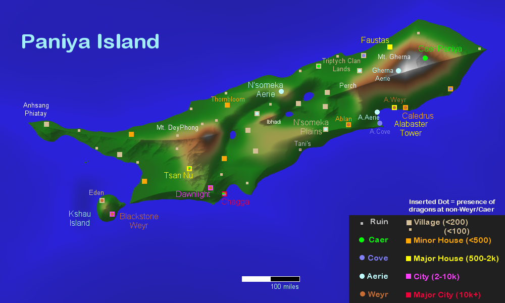
Paniya Island is around 950 miles from west to east, and averages around 200 miles wide though there are areas that vary from 150 to 300. Most of the island is quite fertile, the two higher peaks were volcanic but only in ancient prehistory for the island's purposes, and are dormant now. The indications of population are approximate, and there are quite a few more smaller villages and hamlets, houses and fishing communities around the entire coastline of this island. While some are unnamed, many of the major population centers are 'added' from the Old World with the great transfer of the Protectorate dragonries and communities. The local population was nearly 1 million, and that has increased over time with the influx of three major populations (the Blackstone/Dawnlight group, the Alabaster group, and the Triptych/Faustas group). However the disparate populations have only barely begun to interact let alone become integrated with one another. The Triptych clan did arrive earlier than the rest, and definitely has a presence mixed with the N'somekans.
Features
-- Mt. Gherna, situated on the eastern bulb of the island where Caer Paniya was built, is large and rugged, with strong winds and is tall enough for snow year round at its peak. Its towering and sharp peak has a scoop shaped 'dent' and in that area is where the Caer was built. The Caer is slightly above the snow line but built into the formerly-volcanic mountain, and is comfortably warm even in winter months. Many training and equipment facilities are scattered around the 'scoop', and the Caer itself houses nearly 30 thousand people (most of which are not riders), and almost 2 thousand dragons bred and born here before the Kshau Protectorate's arrival. Note well that dragons overall were not bonded here before Qalam brought them. Though their lineage likely did stem from this larger island they had moved entirely to Mak at some point, so this is a re-established breeding ground, rather than a newly conquered one. The Gherna Aerie is gryphon only, there are no human inhabitants known.
(translates to 'encircle' from Hindi, this mountain protects the island from eastern threats. *also note that this was spelled differently in prior versions)
-- Perch, this location is not a singular peak but is the entire strip of higher ground that separates north from south on the western face of Gherna. The valley on the southern end is quite wet most of the year, while the northern area is dryer and has strong winds that circulate clockwise, beating the Plains heading westward and battering the DeyPhong cliffs.
-- Alabaster Sea, on the southern coast below the towering Gherna is a wide and shallow sea, with many small inlets, peninsulas, and scattered with islands. This area is heavily affected by storm activity but less in the way of tidal changes, due to the sea's eastern and southern 'borders' right under the surface protecting it. However that protection is also why a port was not established here, and instead is farther west - sea dragons might be able to navigate the reefs and shallows, but even though the full sea and its shores are deep enough past them, getting past those shallow reefs is nearly impossible for any human-driven ship. This area was not named before the Protectorate arrived. Alabaster and its accompanying locations moved whole-cloth, and is the 'same' as it had been on the Old World, only ... 90 degrees rotated.
-- N'someka Mountain and Aerie, centrally resting north of the fallen plains, on an overlook rather than a peak. Though there is a higher peak slightly south of this spot, called Ibhadi, it is widely regarded as both 'bad luck' to visit, and 'too dangerous even for gryphons', a spot that has proven to still be apt to tremble or collapse slowly. N'someka itself is not a single peak but a series of smaller jagged ones, where the land has clearly flip flopped on several geologic occasions and is clearly visible in its many strata. However all of them are well covered with lush greenery, tall trees, and riddled with underground caverns. Excellent nesting locations, in other words! The human population of this area is only around 5 thousand total, but they are outnumbered at least 10 to 1 by the various breeds of gryphons.
(various translations from Zulu and other related language groups bring this word numerous meanings: 'to hang out', 'I'm reading', 'to teach'. All of them appropriate!)
-- N'someka Plains, the middle of Paniya is more dry than the coasts and mountains, more than likely due to the upheaval that caused much of it to sink. There is ample water most of the year, but certain portions of this area drain very quickly, and the winds moving over the entire area tend to dry the dirt and plant life out. While it is not a desert, it can be described at best as scrubland in its center, and reasonably dry grasslands otherwise. Several large freshwater lakes are obvious and quite well stocked with fish and wildlife, and the areas below the mountains are, by contrast, extremely wet for most of the year. The bulk of the N'somekan people reside on this lower area.
-- South Central Coast, the southern face of the island is considerably higher and towers over the water for several hundred miles. While plentiful sea birds and some number of gryphons reside on those cliffs, the wind and elements brought from the sea make it nearly impossible for human habitation. The exception is the ruin of Mama Tani's place, which had appeared but then has been rendered to a portal, this location is not very well suited to anyone with two legs. It seems likely that there was another 'half' of the island south of this place, but it collapsed into the sea long ago. The ground on the top of this entire area is beautifully rugged and fertile on either side of the N'someka windswept plains, though trees tend to be shorter and twisted, not great for building.
-- North Central Coast, the more rolling hills and gentle landscape on this side of the island have been populated by bold hunters and outdoorsmen alike for quite a while. Only toward the west has the place been truly formed to Human liking, with massive fields of flowers supporting the House there, and dozens of very small villages working with bees, bats, and other pollinators to support this venture.
-- Mt. DeyPhong on the south-western side of the island is lower and rolling with a lot of greenery and towering trees, very well suited to cultivation on terraces. The eastern face of this mountain plummets deeply into the N'someka plains with waterfalls and high cliffs, suitable for gryphon training flights with their strong winds beating against the mountain. There is evidence that the plains dropped abruptly during a volcanic or geological event hundreds of thousands of years prior, but little to no further activity has plagued the area, similarly to the eastern volcano. While there is usually rain around this mountain, there is only infrequent snow on the sharp jagged peak, though it's still rather dangerous to attempt to climb.
(đề phòng translates to precaution from Vietnamese, as there are lookout towers and patrols that monitor the west from it.)
-- Tsan Nu's territory, sometimes called The Mothwoods, is dense with mulberry and other plants that various breeds of silk worms or arachnids are grown to produce the fabrics and fibers for the fashion houses here. You would be hard pressed to locate all the villages and houses here, as many of them are covered in vines, woven into the very trees, or even tucked under grass and garden roofs. There is a lot of low clouds and fog in the weather conditions of this area, and exotic birds sometimes break the silence and echo under that cover. The architecture of the Tsan Nu area can be tracked back to Chinese, Japanese, and sometimes Korean styles, as can the cultural influences. While the area is not particularly isolated, it is somewhat insulated by the forbidding clouds and terraced hills.
-- City of Dawnlight, moved whole as the Alabaster Tower, Blackstone, and Eden were, this octagonal walled city has been known to lapse across dimensions already. It rests on a plateau edging downward to the coast with two rivers surrounding it and reasonably flat land for plentiful farms. Generally speaking this city is sedate and insular, quite similarly to Tsan Nu... However it also sports a disporportionate amount of dragonrider potentials, and has begun etching out cavernous homes in the higher hills to the northwest for those who remain citizens here to live with their dragons. Others move off to Blackstone. The city sports around 8 thousand people, but has room to grow.
-- Chagga Sea, also known as the Coffee Coast, is a sheltered sea that has a more even depth than Alabaster's area and is easily navigated by even large ships, however it is affected by tidal changes more easily. The city of Chagga is in an area that has several islands and narrows, while the Sea itself is much bigger than just its port. This is a very busy sea, and has several villages with lighthouses along the coast to aid in the safe arrival of ships.
-- Anhsang Phiatay, the northern west peak may be where the majority of seaborne gryphons had roosted for generations, and is now possibly the site of a nexus portal different from Blackstone's? No one knows, but it does have a reasonable presence of people on it gathered at its peak as well as around the shores of both north and south sections of the long peninsula connecting it to the mainland.
(light in the west, vietnamese)
-- Western Coast, while there is a significant House here it remains unnamed. Much of the weather here is rain from the west, which combines with the winds pushing toward this area, likely why the Tsan Nu area is covered with clouds most of its year. There are definitely people living in this area, but no one really knows whether they call the House nearby 'theirs'. This is mostly light forest and marsh, though not wetlands in the same way as the center of the island since the waterways here are formed by the runoff from DeyPhong meandering to deltas on the west.
-- The Kshau Island, claimed by the Protectorate, houses quite a few dragons and groups of people from the Dawnlight community. Mainly dragon riders and their families, this island is more than big enough for Blackstone Weyr and its secrets, at least one full cavernous records-chamber within the mountain top overlaps dimensionally with the Healing Den, so there's that. While the island looks rather like a pointed hat from some angles, it's got more than enough flat land to work with and has inhabitants, even dragon riding ones, who have made their homes outside the Weyr proper. It is mostly evergreens and greatly resembles islands off the Pacific North West on Earth.